Selasa, 20 Desember 2011

The Palm Jumeirah Islands - United Arab Emirates

|0 komentar
The Palm Jumeirah Islands - United Arab Emirates | THE AMAZING ISLAND | The Palm Islands are an artificial archipelago in Dubai, United Arab Emirates on which major commercial and residential infrastructures will be constructed. They are being constructed by Nakheel Properties, a property developer in the United Arab Emirates, who hired Belgian and Dutch dredging and marine contractor Jan De Nul and Van Oord, some of the world's specialists in land reclamation. The islands are the Palm Jumeirah, the Palm Jebel Ali and the Palm Deira. Each settlement will be in the shape of a palm tree, topped with a crescent, and will have a large number of residential, leisure and entertainment centers. The Palm Islands are located off the coast of The United Arab Emirates in the Persian Gulf and will add 520 kilometers of beaches to the city of Dubai.

The Palm Jumeirah Island
The first two islands will comprise approximately 100 million cubic meters of rock and sand. Palm Deira will be composed of approximately 1 billion cubic meters of rock and sand. All materials will be quarried in the UAE. Among the three islands there will be over 100 luxury hotels, exclusive residential beach side villas and apartments, marinas, water theme parks, restaurants, shopping malls, sports facilities and health spas. The creation of the Palm Jumeirah began in June 2001. Shortly after, the Palm Jebel Ali was announced and reclamation work began. The Palm Deira, which is planned to have a surface area of 46.35 square kilometres, was announced for development in October 2004. Construction was originally planned to take 10–15 years, but that was before the impact of the global credit crunch hit Dubai.

The Palm Jumeirah Island
The Palm Jumeirah ( Coordinates: 25°06′28″N 55°08′15″E ) consists of a tree trunk, a crown with 16 fronds, and a surrounding crescent island that forms an 11 kilometer-long breakwater. The island itself is 5 kilometers by 5 kilometers. It will add 78 kilometers to the Dubai coastline. The first phase of development on the Palm Jumeirah will create 4,000 residences with a combination of villas and apartments over the next 3 to 4 years. Residents began moving into their Palm Jumeirah properties at the end of 2006, five years after land reclamation began, according to project developer Nakheel Properties. This signaled the end of phase one of construction, which includes approximately 1,400 villas on 11 of the fronds of the island and roughly 2,500 shoreline apartments in 20 buildings on the east side of the trunk. Nakheel Properties will mark the arrival of the first residents by bringing one of the world's largest airships to Dubai. It has agreed to a deal with Airship Management Services Inc. for a 197 feet (60 m) long, 250,000-cubic-foot (7,100 m3) Skyship 600 dirigible.

The Palm Jumeirah Island
According to Nakheel Properties officials, the process of adding 78 kilometers of beach is under way, while eight of the 32 hotels on The Palm Jumeirah have begun construction, including the Taj Exotica Resort and Spa, which was planned for completion in late 2008 or early 2009, is delayed and now expected to open in early 2010. The first phase Atlantis, The Palm Resort, is scheduled to be completed by December 2008. Atlantis, The Palm opened on 24 September, 2008. The "Golden Mile", the strip of land located along the center of the trunk overlooking the canal, is set for completion in the first quarter of 2008. The tenants started moving in 30 April 2009. Construction has also begun on the Palm Jumeirah Monorail, which will take three years to complete and will serve as a transit system between the Gateway Station at the trunk of The Palm Jumeirah and the Atlantis Station on the crescent. (Emirates News Agency, WAM).The Monorail opened May 6 2009 only using Atlantis Hotel and Gateway Towers Stations.

Dubai World Island - United Arab Emirates

|0 komentar
Dubai World Island -  United Arab Emirates | THE AMAZING ISLAND Dubai World  is an investment company that manages and supervises a portfolio of businesses and projects for the Dubai government across a wide range of industry segments and projects that promote Dubai as a hub for commerce and trading. It is the emirate's flag bearer in global investments and has a central role in the direction of Dubai's economy. Assets include DP World, which caused considerable controversy when trying to take over six US ports, and Nakheel, its property arm, which built The Palm Islands and The World developments, and Istithmar World, its investment company. It is chaired by Ahmed bin Saeed Al Maktoum. Dubai World was established under a decree ratified on 2 March 2006 by Sheikh Mohammed bin Rashid Al Maktoum, Vice President and Prime Minister of the United Arab Emirates and Ruler of Dubai. He also holds the majority stake in Dubai World.

Dubai World
On 2 July 2006, it was launched as a holding company with more than 50,000 employees in over 100 cities around the globe. The group now has extensive real estate investments in the United States, the United Kingdom and South Africa. Dubai World made headlines in March 2008 after its chairman, Sultan Ahmed bin Sulayem, threatened to take the fund's money out of Europe. Dubai World's threats came shortly after the European Union attempted to lay out "a set of principles for transparency, predictability and accountability" for sovereign wealth funds. On November 26, 2009, Dubai World proposed to delay repayment of its debt, which raised the risk of the largest government default since the Argentine debt restructuring in 2001. Dubai World, the investment vehicle for the emirate, asked to delay for six months payment on $26 billion of debt.

Dubai World
The extent of the debt rattled many markets causing many indices to drop; including oil prices. U.S. stocks fell sharply but rebounded from their lows as investors concluded that the damage might be contained. The Dow Jones industrial average lost about 155 points, or roughly 1.5 percent, in a shortened trading day, and other stock averages also sank. Oil prices plunged as much as 7 percent before recovering some ground later in the day. On December 12, 2010, Dubai named Sheikh Ahmed bin Saeed Al Maktoum, head of Emirates airline and uncle of the state’s ruler, as chairman of Dubai World in a board revamp a year after the company said it would halt loan repayments, roiling markets. The 51-year-old replaced Sultan Ahmed bin Sulayem.

Anibare Bay - Republic of Nauru

|0 komentar
Anibare Bay - Republic of Nauru | THE AMAZING ISLANDAnibare Bay is located in Anibare which is one of the districts of Nauru. Anibare Bay is the best beach of Nauru. You can enjoy the best panoramas of Nauru while visiting the beautiful Anibare Bay. The activities which you can enjoy most in Anibare Bay are surfing or swimming but you should be very careful while surfing or swimming as strong surf and underwater current often take surfers by surprise in the Anibare bay of Nauru. 

Anibare Bay
Anibare Bay is situated adjacent to Buada Lagoon which is another greatest attraction of Nauru. Visitors enjoy the beauty of Anibare both during day and night. At night the beauty of the Bay bathed in the rays of the moon is simply mesmerizing. Daytime activities are also various and plenty. Sitting in a full moon night at Anibare Bay gives a very romantic feeling. Anibare Bay is situated adjacent to Buada Lagoon which is another greatest attraction of Nauru. In the Anibare Bay, Nauru you can get to see the variety of submerged flora. 

Anibare Bay
The white coral sand of Anibare Bay makes the beach much more attractive. There is a copiousness of sunlight, sand and shadow in the Anibare Bay at Nauru. Anibare harbor is another attraction of Anibare Bay. You can put up in the Meneng hotel during your visit to Anibare Bay in Nauru. Meneng hotel is situated very close to Anibare Bay. Sitting in your hotel room you can enjoy the excellent view of Anibare Bay. The accommodation and service of this hotel are extremely satisfactory. 

Bouvet Island - Norwegia

|0 komentar
Bouvet Island - Norwegia | THE AMAZING ISLANDBouvet Island is located at 54°26S 3°24E / 54.433°S 3.4°E / -54.433; 3.4. It is 49 km2 (19 sq mi) in area, 93% of which is covered by glaciers, which block the south and east coasts.[4] A number of rocks and very small satellite islands lie offshore, including Lars Island to the southwest. The nearest land is Queen Maud Land, Antarctica, which is over 1,750 kilometres (1,090 mi) away to the south, and which does not have a permanent population but is the site of a Norwegian all-year research station. To the northeast, it is about 2,500 kilometres (1,600 mi) to Cape Town. Bouvet Island has no ports or harbours, only offshore anchorages, and is therefore difficult to approach. Wave action has created a very steep coast. The easiest way to access the island is with a helicopter from a ship. The glaciers form a thick ice layer falling in high cliffs into the sea or onto the black beaches of volcanic sand. The 29.6 km (18.4 miles) of coastline are often surrounded by pack ice. The highest point on the island is called Olavtoppen, and has a peak 780 m (2,559 ft) above sea level. A lava shelf on the island's west coast formed between 1955 and 1958 and provides a nesting site for birds.

Bouvet Island
Because of the harsh climate and ice-bound terrain, vegetation is limited to lichens and mosses. Seals, seabirds and penguins are the only vertebrate fauna. As such the island is part of the Scotia Sea Islands tundra ecoregion, along with South Georgia and the South Sandwich Islands, the South Shetland Islands and the South Orkney Islands. Despite being uninhabited, Bouvet Island has the unused Internet country code top-level domain (ccTLD) .bv. It also has an amateur radio prefix, 3Y, and a few amateur radio expeditions have travelled to the island to use it. There is no telephone country code or area code, no telephone connection (except through satellite) and no postal code nor postal distribution. Bouvet Island is according to Norwegian law in the UTC+01 time zone. The first extended stay on the island was in 1927, when the Norwegian crew of the ship Norvegia stayed for about a month. The island was claimed for Norway by expedition leader Lars Christensen on 1 December 1927 By a Royal Norwegian Decree of January 23, 1928, Bouvet Island (Bouvetøya in Norwegian) became a Norwegian Territory. The United Kingdom waived its claim in favour of Norway the following year. In 1930 a Norwegian act was passed that made the island a dependent area subject to the sovereignty of the Kingdom (but not a part of the Kingdom).

Bouvet Island
In 1964, an abandoned lifeboat was discovered on the island although its origin has never been determined. In 1971, Bouvet Island and the adjacent territorial waters were designated a nature reserve. During the 1950s and 1960s, there was some interest from South Africa to establish a weather station, but conditions were deemed to be too hostile. An automated weather station was, however, set up in 1977 by the Norwegians. On September 22, 1979, a satellite recorded a flash of light (which was later interpreted as having been caused by a nuclear bomb explosion or natural event such as a meteor) in a stretch of the southern Atlantic Ocean between Bouvet Island and Prince Edward Islands. This flash, since dubbed the Vela Incident, is still not completely resolved. In 1994, the Norwegians constructed a field station – a container building of 36 square metres (388 square feet). On October 19, 2007, the Norwegian Polar Institute announced that the station was no longer visible on satellite photographs. Later investigations indicated that a landslide or ice avalanche swept the building off its foundations. A replacement station is being planned (2009). An unmanned weather station on the island is reportedly still intact.

Bouvet Island
Bouvet is the setting of the 2004 movie Alien vs. Predator, in which it is referred to using its Norwegian name "Bouvetøya" even though in the unrated edition of the film, a satellite focuses in on the island which is geographically situated in the approximate location of Peter I Island. In 1990, a multi-nation expedition of five Amateur Radio Operators landed on Bouvet to set up communications with the world. They were assisted by their ship, the Norwegian Vessel, the Aurora, carrying a helicopter to off load men and equipment to the island. The operators were Jon Petter Åsen, Yvonne Edvartsen, Lena Aronsen, Håkon Bogen, Nikolai Røed Kristiansen. In 16 days on the island, they contacted 50,000 Amateur Radio Operators around the world on SSB, CW, and RTTY. Scientists were on the ship and mapped the population of Seals and Penguins during their stay. There was also a film crew along to document the expedition for Movies and TV.

Gunkajima Island - Japan

|0 komentar
Gunkajima Island - Japan | THE AMAZING ISLANDGunkanjima (the Ghost and forbidden Island) is one among 505 uninhabited islands in the Nagasaki Prefecture about 15 kilometers from Nagasaki itself. The island was populated from 1887 to 1974 as a coal mining facility. The island's most notable features are the abandoned concrete buildings and the sea wall surrounding it. It is known for its coal mines and their operation during the industrialization of Japan. Mitsubishi bought the island in 1890 and began the project, the aim of which was retrieving coal from the bottom of the sea. They built Japan's first large concrete building, a block of apartments in 1916 to accommodate their burgeoning ranks of workers, and to protect against typhoon destruction.

Gunkajima Island
Gunkanjima is one among 505 uninhabited islands in the Nagasaki Prefecture about 15 kilometers from Nagasaki itself. The island was populated from 1887 to 1974 as a coal mining facility. The island's most notable features are the abandoned concrete buildings and the sea wall surrounding it. It is known for its coal mines and their operation during the industrialization of Japan. Mitsubishi bought the island in 1890 and began the project, the aim of which was retrieving coal from the bottom of the sea. They built Japan's first large concrete building, a block of apartments in 1916 to accommodate their burgeoning ranks of workers, and to protect against typhoon destruction. 

Gunkajima Island
In 1959, its population density was 835 people per hectare for the whole island, or 1,391 per hectare for the residential district, one of the highest population density ever recorded worldwide. As petroleum replaced coal in Japan in the 1960s, coal mines began shutting down all over the country, and Hashima's mines were no exception. Mitsubishi officially announced the closing of the mine in 1974, and today it is empty and bare, which is why it's called the Ghost Island. Travel to Hashima is currently prohibited.

Senin, 19 Desember 2011

Felicite Island - Republic of Seychelles

|0 komentar
Felicite Island - Republic of Seychelles | THE AMAZING ISLANDFelicite Island is situated 4 km away from the La Digue. This Island is also positioned with a close proximity to some other La Digue satellites like Marianne, Sister Islands, and Ile Cocos. It has many wonderful sites that you can go for sightseeing. There are many lavishly framed structures that are really outstanding and eye-catching. Felicite has gorgeous beaches at La Digue, and can offer you swimming and snorkeling facilities also. Felicite Island is only for snorkeling enthusiasts, hikers, and the very rich. It’s covered with the mountainous terrain, which is surrounded by the excellent snorkeling places and also owned by the luxury resort named La Digue Island Lodge. The guests who stay at the lodge that is situated on the La Digue Island can get a good chance to walk over beautiful trails while enjoying snorkeling, and taking full advantage of enjoying the private island where they are for a short time.

Felicite Island
At the time you book for the Felicite Private Island you will be very lucky enough to encounter some of the unique services and awesome nature’s gift. The Felicite is a French word that denotes bliss. Therefore staying here is completely blissful, with comfortable accommodation and staff set to cater your need. At less than 3 square kilometers, this charming island, which is just like heaven, sits proud in the center of most toured islands of Seychelles. It can offer you an overall panoramic sight of La Digue, Praslin, Sisters and finally Coco Island. Coco island is comprised of some of the beautiful aquatic world. This natural aquatic world is a very famous snorkeling place in the area of Seychelles. However, the Felicite Island has lots more to give than only its gorgeous seas, your Robinson Crusoe Island.

Felicite Island
Many beaches have amazing swimming and snorkeling facilities you can enjoy. You can feel on top of this world with just 10 minutes of walk from your accommodations. This island is filled with richness given by the fertile land and you will grow to love the many seasonal local fruits and vegetables practically right at your door step; and then feel it, see it, and eat it from your Garden of Eden. Four Palm thatched A-frame style chalets with attic and patio is nicely included amongst the natural boulders and plants, overlooking Coco Islands and its Marine Park. Chalets are perfect for couples and families of four or five. Serving to your taste, the chef and his entire crew are at your beck and call in a very informal and familiar manner. But, they are well aware of preserving your privacy and keeping a touch of fine wining and dining. Felicité is densely forested, and it is perfect for exploration. Also there are lots of lovely beaches and interesting nooks and crannies to find, few of which are not readily accessible. They are also therefore extremely private. Maybe the best-looking beach, the La Penice, is located just hundred meters from bungalow accommodation and with mere two bungalows giving accommodation for eight people ensuring quiet a good holiday.

Tayrona Park Island - Colombia

|0 komentar
Tayrona Park Island - Colombia | THE AMAZING ISLAND | The popular Tayrona Park lies at the Caribbean coast near Santa Marta in Colombia. It has some of South America's loveliest coastline. This little, delightful spot is located about 30 minutes from the city of Rodadero, with beautiful beaches, hammocks to rent for the night, food, water and surf (be careful, though; there is a strong riptide - experienced surfers only!). Additionally, you can get a guide to take you to a native village in the nearby mountains The variety of fauna and flora due to the 15 000 hectares declared as a national park in 1964 (12 billion land and sea girdle 3 000) extend from sea level to 900 meters, allowing the existence of different land and sea ecosystems.

Tayona Island
The park is represented by two drainage systems. The maritime system, consisting of sets of small streams, creeks and streams that glide slopes, rocky gorges and flow into the sea. In the west, the existing river channel are reduced and remain dry for much of the year, because of the ruling regime at (bonitogordo broken, shell and Gayraca). In times marked by drought, the creek water infiltrating shell in deep sandy sediments of the seabed and are invisible to the sea and reappear in small ponds near the beach. To the east of Gayraca, flow rates gradually increase and become perennial. History this park is the concession of the Tayrona National Park was created in 1964 and it is located on the Caribbean Coast in the north of Colombia, only 34 km from the city of Santa Marta. it has not only an immense natural importance in this region, but it is also a cultural treasure. A long time ago, small groups of hunters and gatherers inhabited the park, and towards the VI and the VII century, both the coast and the mountain of the park were habited by the famous Tayrona tribe. You can admire their culture nowadays, because the Koguis, their direct descendants, as well as three other indigenous groups, still live in these areas and they maintain many of their traditions.

Tayona Island
The continental drainage system consists of the streams that will lead to the river stones, and to serve eastern boundary. At the western end of River Park average annual precipitation is about 500 mm. She is gradually increasing to the east to levels approximately 2000 mm in the field of river stones and highest mountain landscapes of central and eastern portions of the area. In two rainy periods are May 1 to June and the other from September to November, with maximum intensities in October, and two dry periods, the first of December to April, more intense, and the other called Indian summer, quite variable and may even be limited to just two weeks in July or early August. The average annual temperature at sea level is 27 ° C, and is estimated at about 22 ° C for the high peaks of the park.

Fernando de Noronha - Brazil

|0 komentar
Fernando de Noronha - Brazil | THE AMAZING ISLANDTwo hundred some miles off Natal on Brazil's northeastern coast, in waters untainted by sediment from Brazil's major rivers, lies Fernando de Noronha, an archipelago looking today much like it did when it was discovered five hundred years ago. Its distance from shore and the limited tourist facilities aren't a drawback to visitors who rave enthusiastically about these spectacular islands. The archipelago is called Fernando de Noronha (see map.) The islands are the remains of volcanic mountains jutting up from the Atlantic. There are twenty small islands, one larger one, and scores of beautiful beaches where clean sand, pure water and fabulous marine life abound.

Fernando de Noronha
Claimed by Américo Vespúcio for the Portuguese in 1503, early settlers built a fortress, now in ruins, at Vila dos Remedios, the largest populated town. (See map.) The islands were a prison, then a convenient stopover point for early flights to Europe, and the facilities used by one European airline gave the name AirFrance to a local community. There was also a WW II air base. Today, the Brazilian Air Force maintains a base there. Although the islands support a large variety of wildlife species, they are relatively unpopulated and tourism is restricted to 420 visitors at a time. In fact, the longer you stay, the higher your permit fee will go. There is one paved road, Brazil's shortest national highway, one hotel and many pousadas which fill to capacity in the summer season.

Fernando de Noronha
In the 1970's almost three-quarters of the archipelgo was created into the National Marine Sanctuary of Fernando de Noronha, the PN Fernando de Noronha, to preserve both the land and marine environment. Of particular interest is the nature conservancy effort saving the sea turtles (shown above. Click on the thumbnail for a larger image and description.) While Fernando de Noronha is now a model environmental protection area, it is also one of Brazil's almost hidden treasure. The clarity and warmth of the water, on the equatorial stream, and the abundant underwater life makes these islands a mecca for divers and snorkelers. There are over two hundred species of fish, plus dolphins, sea turtles, and sharks to view and photograph.

Freedom Island - Thailand

|0 komentar
Freedom Island - Thailand | THE AMAZING ISLAND | Longtail boat from Patong Beach cost 1,300-2,000 baht, it all depends how many you are and your negotiations skills. The 6 km boat trip should take around 15 minutes around the headland at the southern tip of Patong Bay. A shorter and cheaper alternative is to take a longtail boat from Tri Trang Beach only 1,3 km away.  There is a road going to Freedom Beach, but a locked gate prevents tourists from driving to the beach.  Freedom is the most beautiful beach in Phuket with white soft sand, crystal clear water and the beach is kept in perfect order, no garbage here. It can't get any cleaner and the people that is running the beach make sure it stay so.
Freedom Island
Freedom Beach is located in a cove south of Patong, at the foot of a lush green hill where sunbeds are placed under the palm trees and not directly on the beach itself, leaving the beach mostly empty with the exception of sun lovers like myself.  The beach has facilities like a restaurant, modern toilets and showers at the end of the beach. There are no water sports at Freedom Beach and jet skies from Patong are not welcome here. As soon as jet skies come close to the beach the staff run down and chase them away. Freedom is a quiet beach where the whole family can relax in the sun without being disturbed by beach vendors trying to sell overpriced wares. 

Freedom Island
Lots of corals in shallow water was destroyed under the tsunami. Now the corals are back, but they are still very small. There are some corals in deeper water but I think there are better places elsewhere even if a friend was impressed by the snorkeling here. Freedom has very clear water where lots of colorful fish swim close to the beach. But in the shallow water where everyone feed the fish the sand gets stirred up and the water loses its clarity. Instead you should swim out a few meters where the visibility is much better or swim where there are less people.  Freedom is one of the most expensive beaches in Phuket to spend a day on. Sunbed 120 baht, food in the restaurant is very expensive, longtailboat cost alot. This is not a beach one can visit often so long the road is closed for tourists. There is only one thing I would point my finger on and that is the very expencive and tasteless food. One example: French fries, the only food I eat on a beach in Thailand cost more than in a fast food outlet back home in Norway! 

Wineglass Bay Island - Australia

|0 komentar
Wineglass Bay Island - Australia | THE AMAZING ISLANDWineglass Bay, along with Cradle Mountain, is recognised across the world as one of Tasmania’s iconic destinations. But, there is more to this east coast gem than simply capturing your perfect-postcard snap from the lookout. Located in Freycinet National  Park, the region is so naturally stunning and blissfully pure that it’s easy to feel as if you are an early French explorer first setting foot on Wineglass  Bay.  Wineglass Bay  is approximately 2.5 hours drive from Tasmania’s capital,  Hobart (195 kilometres/121 miles) and around two hours’ drive (175  kilometres/109 miles) from Launceston in Tasmania’s north.

Wineglass Bay
It is a region that retains  the adventurous spirit of those early explorers, and today you can discover   Wineglass Bay your own way. Set out on foot and head for  Wineglass Bay Lookout,  allowing yourself over two hours to wander down onto the beach below. Watch for  wildlife including white-bellied sea-eagles, quolls, wallabies, wombats and  Tasmanian devils. Or, take to the water on a scenic cruise where you might be  lucky enough to witness dolphins diving or a pod of migrating whales in the  clearest water you’ll see anywhere. Take the gourmet approach and  experience a guided walk to  Wineglass Bay , including a fine banquet offering  premium Tasmanian cool-climate wines and the freshest crayfish, abalone,  scallops and oysters plucked directly from east coast waters.

Wineglass Bay
The story of  Wineglass Bay , In 1642, Abel  Tasman explored Tasmania’s east coast and named Schouten Island, a small island  which the French explorer, Nicholas Baudin later landed on in 1802. There were  two senior officers on the Baudin expedition, the Freycinet brothers, one of  which the peninsula was named after.  During the early 1800s, the region was popular amongst whaling parties and from 1842 the  discovery of coal and tin attracted miners. In 1916, the area was declared a  national park, making it Tasmania’s equally oldest, along with Mount Field  National Park.

Minggu, 04 Desember 2011

Phi Phi Island - Thailand

|0 komentar
Phi Phi Island - Thailand | THE AMAZING ISLAND | The Phi Phi Islands are located in Thailand, between the large island of Phuket and the western Andaman Sea coast of the mainland. The islands are administratively part of Krabi province. Ko Phi Phi Don  is the largest island of the group, and is the only island with permanent inhabitants, although the beaches of the second largest island, Ko Phi Phi Lee (or "Ko Phi Phi Leh"), are visited by many people as well. The rest of the islands in the group, including Bida Nok, Bida Noi, and Bamboo Island (Ko Mai Phai), are not much more than large limestone rocks jutting out of the sea.

Phi Phi Island - Thailand
Phi Phi Don was initially populated by Muslim fishermen during the late 1940s, and later became a coconut plantation. The Thai population of Phi Phi Don remains more than 80% Muslim. The actual population however, if counting laborers, especially from the north-east, from the mainland is much more Buddhist these days. The islands came to worldwide prominence when Ko Phi Phi Leh was used as a location for the 2000 British-American film The Beach.

Phi Phi Island - Thailand
This attracted criticism, with claims that the film company had damaged the island's environment, an accusation the film's makers contest. The film's release was attributed to an increase in tourism to the islands. Phi Phi Leh also houses the 'Viking Cave', from which there is a thriving bird's nest soup industry. Ko Phi Phi was devastated by the Indian Ocean Tsunami of December 2004, when nearly all of the island's infrastructure was destroyed. As of 2010 most, but not all, of this has been restored

Klara Island - Indonesia

|0 komentar
Klara Island - Indonesia | THE AMAZING ISLAND | Klara was a stranger to beach lovers of nautical tourism in the country though. To reach here only taken one hour more than Lampung Branti Airport. Unfortunately the beach is not too long promoted by the Local Government Pesawaran newly formed three years ago so tourists know only tourist attractions in Elephant Elephant Conservation Centre in Way Kambas National Park. Klara name taken from the abbreviation of Coconut Meeting. Where the location of this beach is a lot of palm trees that were located close together so as to form a shade canopy or beach. Klara is very safe beach located right on the bay overlooking the West Lampung.

Klara Island - Indonesia
Although the road to get there is not too wide as in the general class of county roads, but conditions are still smooth and no visible holes that disrupt the comfort of the rider. Medium-sized tour bus was very comfortable with this way. But when the vehicle ran into the same size should slightly reduce the speed to pull over onto the shoulder. The atmosphere of a sloping white sandy beach is perfect for a tour of all ages. The waves at this beach can be said absolutely nothing because how in the Bay of Lampung and very far from the Ocean Indonesia. Small waves called ripples may be more suitable it would be really gives a sense of security when carrying a toddler and playing on the beach. Klara beach facilities include an open field shaded by coconut trees Tarusan, gazebo for shelter, food and drink stalls, toilets and ample parking can menapung hundreds of vehicles and personnel security.

Klara Island - Indonesia
For tourists who want to spend the night around the coast of Clare not to worry, though on the coast of Clare there are no inns, cottages and hotels, directly opposite the beach of the island there Klara Pahawang being developed into a marine tourism destination. Only by hiring a boat with a mileage of less than 30 minutes, we've reached the island Pahawang which has facilities menduduk bungalau and homes for rent. Tourist attraction even more diverse ranging from fishing villages, mangroves, white sandy beaches to, fishing, snorkeling and diving spot for.

Borneo Island - Indonesia

|0 komentar

Borneo Island - Indonesia | THE AMAZING ISLANDThe island of Borneo (Kalimantan) is the world's third largest island after Greenland and New Guinea Island. Overall width of Borneo Island is 736,000 KM 2. Borneo island there are also tracks the mountains in the northeast with the highest mountain is Mount Kinabalu with peaks as high as 4175 AD The island is wet tropical with an average temperature of 24-25 degrees centigrade and crossed by the equator. It is known that foreign nations have been in contact with the residents on the island of Borneo since around the 1st century AD.

Borneo Island - Indonesia
Based on historical relics artifacts that had been found, that the oldest artifacts found on the island of Borneo are artifacts of the Kutai Kingdom is from the 4th century AD the wing Hindus, is located on the east coast of the island. Even based on the findings of this historical artifact, that artifact Kutai Kingdom is the oldest artifacts found in this archipelago. In the 8th century AD the kingdom of Srivijaya had an effect along the west coast of Borneo island and in the 14th century AD the kingdom of Majapahit influence almost all over this island. At the beginning of the 16th century AD the people of Europe began to arrive on the island of Borneo.

Based on the euro notes mentioned that the first Europeans who came to the island of Borneo was an Italian named Ludovico de Verthana ie in 1507 AD which was then followed by the Portuguese who named Laurenco de Gomez in the year 1518 AD continued to be followed by the Spaniards who named Ferdinand Magellen in 1519 that is on the way round the world, then followed by the Netherlands, Britain and France. Of the Europeans and the name of Borneo is known since the 15th century AD The name was derived from the name Borneo borneol tree {Latin: Dryobalanops camphora) containing (C10H17.OH) terpetin, materials to be used for antiseptic or perfumed oil and camphor, camphor wood which usually grow in Borneo, later by traders from Europe called the island of Borneo, or borneol-producing islands, from the title of Europe's people of the name of the Kingdom of Brunei, because at that time the kingdom of Brunei is the kingdom of the most dominant / largest on the island so that every stranger who came on this island, will visit the Kingdom of Brunei, so then Brunei's name became an icon for this island which then dipelatkan by the tongue of Europe into Borneo which then continued to be used up to the Dutch colonial occupation of "the island of Borneo".

On July 7, 1607 Dutch expedition led Koopman Michaelszoon Gillis arrived in Banjarmasin, but the entire crew was killed in retaliation for the seizure of the population by the VOC to the two junks anchored at Bantam Banjar tanun 1595. In 1612 at the Sultan Mustain Billah, the Dutch came to Banjarmasin to punish the Sultanate Banjarmasin 1607 and fired over the incident destroyed the Old Banjar (village palace) in Kuin, so the kingdom's capital was moved from Banjarmasin to Banjar Martapura.

Based on the documents that the first written agreement between the people of Europe with the population on the island of Borneo in 1609 AD to do the trade agreement between the Dutch trading company VOC with the King of Queen Sambas Panembahan Sapudak although later that the trade relations between the two sides did not develop. The agreement that both VOCs agreement with the Kingdom on the island of Borneo is the Sultanate signed in Banjarmasin 4 September 1635 at the Sultan Inayatullah. The contents of the contract, among other things, that in addition to the purchase of pepper and about the customs, VOCs will also help the sultanate Banjar to face attacks from outside. VOC activity was further developed in the east than the west island of Borneo which is due east of the island of Borneo border to the center of the world pepper the Maluku Islands.

Borneo Island - Indonesia
At the time of arrival of these European people who started at the beginning of the 16th century AD until the later period of their colonialism until the 20th century AD, the kingdom-the kingdom that is prominent on the island of Borneo in addition to the Sultanate of Brunei Sultanate Banjarmasin, Sukadana Sultanate, Sultanate Sambas and Pontianak Sultanate. In connection with the attack of Napoleon to the Netherlands on the 3rd part of the 18th century AD and then make the whole power of the VOC in this archipelago, including in Borneo on the pull back to the Netherlands and the Dutch position in the archipelago was later replaced by the British. When finished the war with Napoleon, the Netherlands and then occupy its position in this archipelago including the island of Borneo, but this time the Dutch activities are no longer in the name of the VOC, but directly by the Government of the Kingdom of the Netherlands with the name of the Dutch East Indies. In 1819 the Sultan of Pontianak to M-3 (Usman Sharif Sultan Al Qadri) was appointed to lead the Dutch East Indies government Afdeling Pontianak.

Until the year 1839 AD, the influence of power on the island of Borneo is divided into 3 regions namely Next to the southwestern power controlled by the Sultanate of Brunei, northeast controlled by the Sultanate of Sulu and next to the central and southern Dutch East Indies government in control of most of the territory acquired from the Sultan Banjar, Tamjidullah I on October 20, 1756 Agreement. Most of the territory of the Sultanate of Brunei and the Sultanate of Sulu then annexed by James Brooke who became King in Sarawak. Government Activities in the Dutch East Indies island of Borneo is far more aggressive than the VOC ago because it was hard to compete with the Dutch in the capture of British influence in the island of Borneo is especially after the appointment of James Brooke (an Englishman) who became King White in Sarawak in 1841.

To anticipate the expansion of the influence of James Brooke to its territory, then the Dutch East Indies government in 1846 AD and then began traveling the Netherlands Indies Government Expedition Team which borders along the entire edge of the territory held by James Brooke. The first expedition team led by Second Lieutenant D. van Kessel who explored the west and then followed by the expedition team led by Dr. CM. Schwaner who explored the east. At first the central and southern Dutch-controlled island of Borneo is shared by the Government of the Netherlands East Indies in 3 Afdeling ie Afdeling South and East Coast, Afdeling Afdeling Sambas and Pontianak.

Then combine the Netherlands Indies Government Afdeling Afdeling Sambas and Pontianak be named Borneo as a whole Westkust divide its territory is divided into two administrative regions of Borneo Westkust (west Borneo) and Zuid Oostkust Borneo (Borneo next to the central and eastern) this name later changed to Borneo Westerafdeling and ZuidOostterafdeling Borneo. To unite the Borneo region, then in 1894, on the initiative of Damang Stone, from a village in Central Kalimantan tumbles Anoi gather all the people who have a degree tamanggung, Damang, Damboeng, Dohong .. se-borneo, Anoi tumbles in the agreement which was also attended by Afdeling Pontiac, who was still a replacement officer who was imported from Bogor.

Until now heritage sites in tumbles Anoi agreement remains. But for engineering the Dutch government, at that place in the form of Agreement tumbles Anoi betang, destroyed by the Dutch army to deal in tumbles Anoi considered absent. building materials was transferred in part to Kuala Kapuas, but can not transport all the material because it is made from ironwood trunks deeply imbedded soil, a large, heavy and long field through a long river to transport it. At the end of Dutch colonialism on the island of Borneo there are two areas namely Residentie Residentie Residentie Pontianak and Banjarmasin.

Mauritius Beach - Republic of Mauritius

|0 komentar

Mauritius Island - Republic of Mauritius | THE AMAZING ISLANDIf your definition is perfect for this holiday can relax in one of the most beautiful locations that exist anywhere in the world, when you first step into the beach in mauritius you will soon know that it's right where you want! the only catch is that Mauritius does not have "a" beach, he had dozens of them! The only problem that might occur during your holiday mauritius is to decide whether you want to remain in one location, or if you want to explore all the beaches on the island!

Mauritius Island - Republic of Mauritius
there is no more a focus for a vacation from the beach. in mauritius tropical climate, every day at the beach will be filled with a warm and relaxed clock hours, soaking up the sun there is just no other kind of vacation that can reasonably compare the holiday to the beach in mauritius! coast of mauritius has a warm, most white sand you'll ever see! of sand, you'll revel in the beauty of the vast sea in front of you, the warm, crystal-clear water perfect for swimming, superb photography, as well as taking all of it as one of the most spectacular attractions that you may ever see .

Mauritius Island - Republic of Mauritius
If you choose mauritius vacation, you will see that the beach is located across the island itself, and you will also have the option to take a boat to Ile aux cerfs, a small island on the east coast of human mauritius blue lagoons and beautiful beaches very own. Your choice of beaches in mauritius can reflect your own individual preferences. You can choose between the privacy of the long, quiet beach, the beach with shops and an active tourist life, and beaches with a variety of water activities. Which style suits you best, you will find at least one that suits you. You'll even find surfing mauritius center, located at Baie du Tamarin. if you have never seen or experienced surfing game, quite remarkable to watch and fun to try.

Mauritius Island - Republic of Mauritius
as an island located in the Indian Ocean, it should not come as a surprise that mauritius contains some of the most beautiful beaches in the world! should also not come as a surprise which is unique in each is own way, and each has a lot of the right place. You can easily design your own individual vacation packages around the stunning beaches of mauritius. if you want to spend your entire trip at one beach, or go to any beach of this island has to offer, you can be sure that any time you're at the beach will be permanently engraved into the memory as a fun beach vacation you've ever experienced. You will need all the colors of your favorite beach wear and cold drinks, and you can ensure that you are really a holiday in mauritius means life is a beach!

Navagio Island - Yunani

|0 komentar

Navagio Island - Yunani | THE AMAZING ISLAND | The beach with the shipwreck of the metallic ship lying on the beach, semi-buried in the white sand is the most easily recognisable and the most photographed beach in Greece. It is situated at a distance of some 36,5 kilometers northwestern to the town of Zakynthos and 4 kilometers western to Volimes. The beach is accessible only from the sea, but you may also see it from above, standing on the high rocks that overlook it. Apart from the name “Navagio” (meaning shipwreck in Greek), the beach is also known with the name “the Smuggler's Cove”. Only a few remember and nobody use its official name “Aghios Georgios”, as it has been named after the homonymous monastery of Aghios Georgios “ton Krimnon” (“of the cliffs”), found some 2,5 kilometers before arriving to the shipwreck, at the East.

Navagio Island - Yunani 
The story of the shipwreck recalls the old pirate stories of the Venetian period. It was in 1980 when the Greek pursuit authorities detected a ship, suspected for smuggling of cigarettes and liquors, sailing in the open Ionian Sea. They ran after it and, because of the very bad weather, the ship was forced to stand on the sandy beach of the cove, where it lies ever since. It was an old ship, built in 1937 in Scottish shipyards and it had changed various owners until ending up on this peaceful cove, whose became the “trade mark”. Millions of photos of the shipwreck have been made and some people pretend (not without exaggeration!) that the place is more photographed than the Acropolis of Athens and the Parthenon.

Navagio Island - Yunani 
The beach is not organised at all and the thousands of visitors who arrive here to see the shipwreck and swim in a wonderful crystal clear sea, have to bring along the necessary provisions, water above all. Although access is quite difficult, hundreds of visitors arrive here every day. If you decide to swim here, be careful, as the sea is very cold in this area. Also, avoid entering the rusty shipwreck, as it might be dangerous.

Access to the beach is possible only from the sea, by tourist boats running regularly and very frequently in summer; even if the place is not their final destination, all tourist boats sailing in the northern part of Zakynthos, stop at the beach for a while. The boats depart from the port of the town of Zakynthos, from Laganas, from Aghios Nicolaos at Volimes, or from Porto-Vromi. This latter is the closest one: the boats depart to Navagio every hour and the journey lasts some 30 minutes.

Navagio Island - Yunani 
Of course you can arrive here by car (less than 37 kilometers from the town of Zakynthos); you will follow the road plates to “Navagio” and park just before the steep rocks of the shore, on a flat area. After a few minutes walking, you will find a terrace, from where you can admire this original beach from above. The spectacle is worth the visit: you will see the steep white rocks overlooking the small cove with the clear blue sea and shadowing the beach with the white sand and the relics of the ship; a fascinating contrast. Only when you visit it you can fully understand why this place is so famous. No photo can reproduce the variety and the tones of colours, which change dramatically, following the position of the sun and create one of the most amazing landscapes you have ever seen.

Belitong Island - Indonesia

|0 komentar

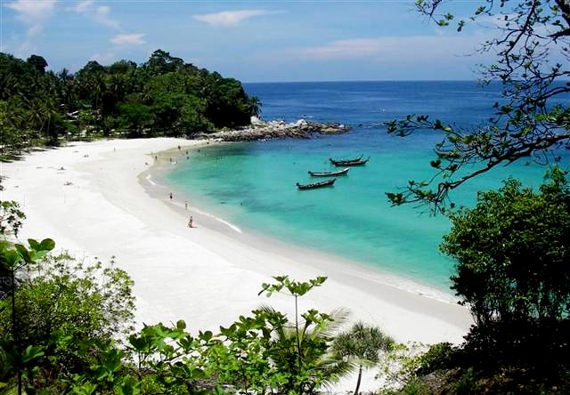
Belitong Island - Indonesia | THE AMAZING ISLAND | Pacific Islands, or Belitong (the local language, named after a type of sea slug), formerly known as Billiton is an island off the east coast of Sumatra, Indonesia, flanked by Gaspar Strait and the Strait of Karimata. The island is famous for its white pepper (Piper sp.) Are in the local language is called sahang, quarrying and mineral type-C as a white tin (Stannuum), quartz sand, white clay (kaolin), and granite. And lately a natural tourist destination alternatives. The island was formerly owned by United Kingdom (1812), before finally exchanged to the Dutch, together Bengkulu, with Singapore and New Amsterdam (now part of New York). Its main town is the Tanjung Pandan. Belitung island is divided into two districts namely District Billiton, capital in Tanjung Pandan, and the Eastern Islands, capital of Manggar.

Belitong Island - Indonesia
Most of its inhabitants, especially those living in coastal areas, are very familiar with the rich marine life with the results of marine fish. A variety of processed foods made from fish into food everyday citizens. The wealth of sea became a source of livelihoods of Pacific Islands. Natural resources are not less important to people's lives Billiton is tin. Of tin mining has been started since the time of the Dutch East Indies. Belitung Island residents are mainly ethnic Malay (spoken with a dialect Islands) and Hokkien and Hakka Chinese descent.

Geographically the island of Billiton (Malay; Belitong) is located at 107 ° 31.5 '- 108 ° 18' east longitude and 2 ° 31.5 '-3 ° 6.5' south latitude. Overall Belitung island wide reach 4800 km ² or 480,010 ha.Pulau Islands to the north bounded by the South China Sea, east by Karimata strait, south by west Java Sea and bordering the strait Gaspar. Around these islands there are small islands such as Pulau Mendanau, Kalimambang, Gresik, Seliu and others.

History
Islands archipelago is experiencing some kings reign. At the end of the 7th century, Billiton was recorded as the kingdom of Srivijaya, Majapahit Empire began later when debuted in 1365, the island became one of the bastions of marine kingdom. Only in the 15th century, Billiton have rights reign. But even then not for long, because when it was ruled by Cakradiningrat Palembang II, the island is soon to be conquered Palembang. Since the 15th century in the Pacific Islands has established an empire that is the Kingdom Badau with Datuk Mayang Geresik as the first king. Central administration is located in the vicinity of the current release. Its control region covers an area Badau, Ibul, Bange, Bentaian, Simpang Tiga, up to Buding, Manggar and Hanging. Some of the historical relics that show traces of royal Badau, berlok 13 form spear, dagger, sword, gong, kelinang, and rakes apostles. Relics can be found at the Museum Badau.

The second kingdom is the kingdom of Beams. King first came from the descendants of Javanese kingdom of Mataram bangsawaan named Islam Masud or Kiai Kiai Agus Agus Ja'kub Gedeh, who holds Depati Cakraningrat I and ruled from 1618-1661. Furthermore, the government is run by Kiai Mending or Depati Cakraningrat Agus II (1661-1696), which move the center of the kingdom of the Old Beams into an area that became known as the New Beams. The next government held by Agus Gending Kiai who holds Depati Cakraningrat III. In the reign of Depati Cakraningrat III, the Islands were divided into 4 Ngabehi, namely:
  • Ngabehi Badau with a degree Ngabehi Land Lion of Judah or Judah;
  • Ngabehi Sijuk with a bachelor's or Krama Ngabehi prey Juda Juda;
  • Ngabehi Buding with a bachelor's Palace Ngabehi Judah.

Each Ngabehi it relegates the kings of the so separated from the Kingdom of Beams. In 1700 Depati Cakraningrat III died and was replaced by Agus Bustam Kiai (Depati Cakraningrat IV). In the reign of Depati Cakraningrat IV, the religion of Islam began to spread across the island of Billiton. Degree Depati Cakraningrat only used up to the king that the beam-9, which is Kiai Agus Mohammad Saleh (title IX Depati Cakraningrat), because in 1873 the title was cleared by the Dutch Government. Beams royal secondarily Kiai Agus Endek (reigned 1879-1890) ranks as the District Head Islands and based in Tanjungpandan.

Belitong Island - Indonesia
The third kingdom is the kingdom Belantu, which is part of the kingdom Ngabehi Beams. The first king was Datuk Ahmad (1705-1741), the title of Datuk Mempawah. Meanwhile, the last king named KA. Umar. Fourth and final kingdom which once stood is the Kingdom Buding, which is part of the territory of the Kingdom Beams. King named Datu Wali vanished slope. Of the four kingdoms that have been mentioned above, the Kingdom of beams is the largest empire that ever existed on the island of Billiton.

In the 17th century, the island of trade routes and the Pacific Islands became a haven of merchants. Of the many merchants, the most influential are the Chinese and Arab traders. This can be evidenced from pottery-pottery that comes from the Sun Dynasty to the 14th century until the 17th, which are found in layers of tin mines in the area Kepenai, Buding, and Coconut Kampit. Based on the records of historians of China named Fei Hsin (1436). While the Chinese people know Belitung due in 1293, Chinese merchants are signed to Island Pacific Islands about the year 1293. A Chinese fleet led by Shi Pi, Ike Mise and Khau Hsing who are traveling to the island of Java, stranded in the waters of Pacific Islands.

Besides the Chinese, who know a lot of other nations were the Dutch island of Billiton. In 1668, a Dutch ship called the 'Zon De Zan messenger', under the leadership of Jan De Marde, arrived in the Islands. They docked at the river Beams, who was the only airport on the island of the Pacific Islands visited by foreign traders. Based Tuntang surrender on 18 September 1821, Island Pacific Islands into the territory of the UK (although the de facto occurred on May 20, 1812). British Resident in the Pacific, siak appoint a king to rule on the small island Pacific Islands because it often happens that people's resistance led by traditional elders. Then based on the Decree of the Commissioner General of the United Kingdom on 17 April 1817, Britain handed Islands to the Kingdom of the Netherlands. Furthermore, in the name of Lady Holland, was appointed a Resident Assistant to run the government on the island of Billiton.

In 1823, a Belgian named Captain JP. De La Motte, who served as Assistant Resident and also head of the Royal Netherlands Army, managed to find a tin on the island. Furthermore, after the Treaty of London 1850, mining was taken over by Billiton Maatschapij, a tin mining company owned by the Dutch Government. At that time the Pacific Islands is divided into 6 areas, namely:
Tanjungpandan and Hanging / Lenggang which is directly under the administration Depati; Badau, Sijuk, Buding and Belantu under their administrations Ngabehi.

In 1890, the rank Ngabehi removed and replaced with the Head of the District. Furthermore, there are 5 districts namely: Tanjungpandaan, Manggar, Buding, sang and Hanging. In 1852 the Pacific Islands are separated from the authority in administrative affairs and tin mining. Separation was at the insistence of JF. Louden (head of the central government in Batavia), to prevent the ill effects of Bangka resident who was envious of the tin mining growing by leaps and bounds in the Pacific Islands. In a series system of the Netherlands East Indies, Pacific Islands in 1921 was made into a district which is headed by a Demat of KA. Adjis Abdul, who assisted two people who supervises two Assistant Demat Onder district, namely the Western Islands and the East Pacific Islands. Gemeente or villages in the Pacific Islands was formed in 1921-1924. Based on Ordinance No. 73 dated February 21, 1924, Billiton is divided into 42 Gemeente.

Belitong Island - Indonesia
In 1933, Billiton changed status into one department Onder-ruled by a Controleur with the rank of Assistant Resident, who is responsible to the Resident of Afdeling Pacific - Pacific Islands are located on the island of Bangka. Dated January 1, 1939 new regulations apply in areas of the Pacific Islands region, which means the island of Billiton has been granted the right to manage their own regions. Of course it affects some circumstances, for example Onder-department covers two districts namely Pacific Islands, Western and Islands District Eastern District Billiton, each headed by a Demat.

Japanese troops occupied the island of Billiton in April 1944, in both the district administration headed by Gunco. In early 1945, Japan established the Lord's People in the Pacific Islands who assist the government. Japanese occupation period is not long, then change back when the Dutch regained control of the Pacific Islands in 1946. In the reign of this Dutch-afdeling Onder Billiton ruled again by the Assistant Resident of the Dutch, while the mastery of the district still held by a Demat which was then replaced with the title Bestuurhoofd.

On November 21, 2000, pursuant to Law No. 27 of 2000, the island of Bangka Islands along with split away and form a new province with the name of the Pacific Islands Province Islands. This province is the province to-31 in Indonesia. Based on the aspirations of the community and the various considerations, Islands District is divided into two districts namely capital in Tanjungpandan Islands District with coverage area includes the five districts and the District of East Belitung with Manggar as its capital with a coverage area includes 4 districts.